Pentire Point
OS Grid ref:- SW934802
 Pentire Point, deriving from the Cornish word Penn Tir, meaning 'headland', is situated near the resort town of Newquay on the Atlantic coast of North Cornwall.
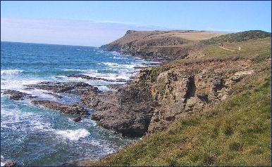
Pentire Point lies to the side of the mouth of the River Camel estuary and is traversed by the South West Coast Path. To the south of Pentire Point lies the small seaside resort of Polzeath. The coastline around the Pentire headland is owned by the National Trust.
Extensive views are to be had from the Point. To the south and west the expanse of Padstow Bay and the mouth of the River Camel are visible. The headland furthest away is Polzeath, the daymark at Stepper Point marks the entrance to the mouth of the estuary. Trevose Head with its lighthouse may also be seen, between Pentire Point and The Rumps several outcrops of pillow lava are visible beside the coast path.
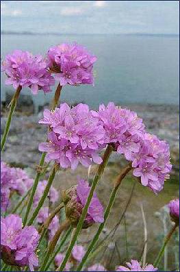
The South West Coast Path closely follows the contours of the headland, and sightseeing boat tours regularly travel along the coast from the nearby port of Padstow. The views along the rock-strewn Atlantic coast of Cornwall are superb and in summer the clifftops are carpeted in sea campion and pink thrift.
 The lower part of the South West Coast Path at Pentire Point passes a collapsed sea cave, one of many on the North Cornish coastline. The cave was carved into the rock by the erosive action of the waves, which then washed around inside it, causing the roof to fall in. The beach at Porth Joke, known locally as 'Polly Joke', derives from the Cornish 'Porth Lojowek', meaning 'cove rich in plants'.
Pentire Point, a Site of Special Scientific Interest, is designated such for its geology and varied flora and fauna including nationally rare plants. At West Pentire, whole fields with vivid scarlet poppies and other rare meadow plants flourish. There is an abundance of sandy grassland at Pentire Point, rich in wild flowers such as cowslip and pyramidal orchid.
Other plants include venus's-looking-glass, shepherd's needle, small -flowered Catchfly and night-flowering catchfly, western ramping-fumitory and the weasel's-snout. At other times the pyramidal orchid and the carline thistle may be seen. Further, towards the coast and on the cliffs rock sea lavender and autumn squill may be sighted while the sand dunes are home to sea holly, henbane and hound's-tongue.
 Birds of Prey and grey seals are often sighted in the area. As are dolphins, porpoises, Basking Sharks, Oceanic Sunfish and large numbers of seabirds. Bottlenose and Common Dolphin are the most likely species to be seen but scarcer species such as Risso's Dolphin do occur occasionally.
Small numbers of Basking Sharks may appear close in shore between April and October. Gannet, Fulmar, Cormorant, Shags, Kittiwake, Razorbill, Guillemot and occasional Puffin can be seen at any time of the year.
.A small island known as Newland is situated around a mile to the north-west of Pentire Point. A further small island named The Mouls lies 300 yards to the north-east of the area known as The Rumps and supports colonies of seabirds. Beyond The Rumps, the coastline veers southeast into Port Quin Bay.
The Rumps at Pentire Point, a prehistoric site, which was excavated between 1963 and 1967, can be accessed across a narrow strip of land. The Iron Aget inhabitants of Cornwall realised its obvious defensive potential and exploited the existing gullies, building a series of ditches and ramparts to protect the approach from landward side. The people that lived on the fort wove cloth and cultivated grain and were self-sufficient. The Rumps was deserted after the Roman invasion of Britain.